Imagine you're a young expectant mother living in rural New York State anxiously awaiting the birth of your child. Then suddenly a week before your due date a series of ice storms occur making the journey to the delivery room treacherous. There's no power, the hospital is running on generator power, you haven't had power in your house for a week. Your due date comes and passes and the baby still hasn't arrived. Next, you're at a normal OB/GYN appointment and you get rushed to the hospital. There still is no power other than that provided by the generator. Your baby is born safe and sound and you take them home. However, there is no power at your home and there won't be for another two weeks. My mother didn't have to imagine this because she lived it and it is how I came into the world.

Downed trees after the ice storm
The North American Ice Storm of 1998 (also known as Great Ice Storm of 1998) was a massive combination of five smaller successive ice storms in January 1998 that struck a relatively narrow swath of land from eastern Ontario to southern Quebec, New Brunswick and Nova Scotia in Canada, and bordering areas from northern New York to central Maine in the United States. Millions were left without power for periods varying from days to several weeks, and in some instances, months. It led to 34 fatalities, a shutdown of activities in large cities like Montreal and Ottawa, and an unprecedented effort in the reconstruction of the power grid.
Freezing rain is common in the Eastern half of Canada and New England, generally occurring at the narrow boundary between cold air from the east and north and moist air from the south. Typically, a warm air mass will travel northward along the Mississippi Valley and overrun a shallow layer of cold air trapped at the surface. On January 4, 1998, an upper-level low system stalled over the Great Lakes, pumping warm and moist air from the Gulf of Mexico toward the upper St. Lawrence Valley. At the same time, a high-pressure center was sitting farther north in Labrador, keeping an easterly flow of very cold air near the surface. For more than 80 hours, steady freezing rain and drizzle fell over an area of several thousand square miles.

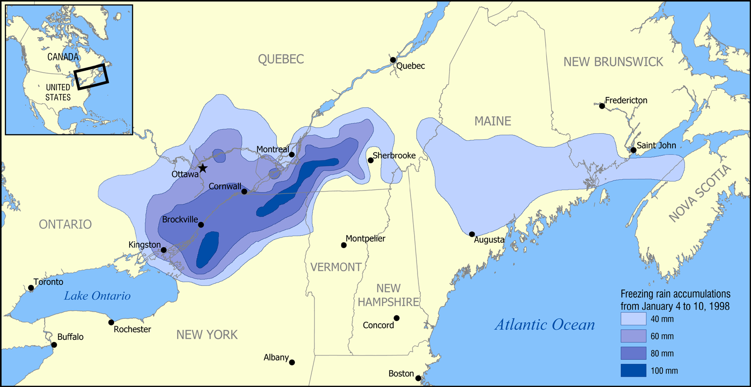
This map shows the accumulation of freezing rain in those areas.
Millions of trees were brought down by the weight of ice around the affected areas. As many trees were damaged or fell by the heavy ice, the maple syrup and orchard regions suffered heavy blows and massive losses in the storm; Quebec's maple sugar industry, the largest in the world, was devastated.
Resources:
Abley, Mark (1998). The Ice Storm: A Historic Record in Photographs of January 1998. Toronto: M&S. ISBN 978-0-7710-6100-4.
Burlington, Vermont National Weather Service (2008). "10th Anniversary of the Devastating 1998 Ice Storm in the Northeast" (PDF). NOAA.
McCready, Jim (2004). "Ice Storm 1998: Lessons learned" (PDF). Eastern Ontario Model Forest.
Downed trees after the ice storm
The North American Ice Storm of 1998 (also known as Great Ice Storm of 1998) was a massive combination of five smaller successive ice storms in January 1998 that struck a relatively narrow swath of land from eastern Ontario to southern Quebec, New Brunswick and Nova Scotia in Canada, and bordering areas from northern New York to central Maine in the United States. Millions were left without power for periods varying from days to several weeks, and in some instances, months. It led to 34 fatalities, a shutdown of activities in large cities like Montreal and Ottawa, and an unprecedented effort in the reconstruction of the power grid.
Freezing rain is common in the Eastern half of Canada and New England, generally occurring at the narrow boundary between cold air from the east and north and moist air from the south. Typically, a warm air mass will travel northward along the Mississippi Valley and overrun a shallow layer of cold air trapped at the surface. On January 4, 1998, an upper-level low system stalled over the Great Lakes, pumping warm and moist air from the Gulf of Mexico toward the upper St. Lawrence Valley. At the same time, a high-pressure center was sitting farther north in Labrador, keeping an easterly flow of very cold air near the surface. For more than 80 hours, steady freezing rain and drizzle fell over an area of several thousand square miles.

This map shows the accumulation of freezing rain in those areas.
Millions of trees were brought down by the weight of ice around the affected areas. As many trees were damaged or fell by the heavy ice, the maple syrup and orchard regions suffered heavy blows and massive losses in the storm; Quebec's maple sugar industry, the largest in the world, was devastated.
Resources:
Abley, Mark (1998). The Ice Storm: A Historic Record in Photographs of January 1998. Toronto: M&S. ISBN 978-0-7710-6100-4.
Burlington, Vermont National Weather Service (2008). "10th Anniversary of the Devastating 1998 Ice Storm in the Northeast" (PDF). NOAA.
McCready, Jim (2004). "Ice Storm 1998: Lessons learned" (PDF). Eastern Ontario Model Forest.
Comments
Post a Comment