San Francisco is one of the most visited cities in the world today and is one of the most expensive to live in. It has an interesting story to tell when it comes to natural hazards and disasters.
The main things people always ask about or comment on when I mention I am from the Bay Area revolve around why it is so expensive to live in San Francisco. The city has recognized appreciated property values which have, in turn, made its individual residents who make under $82,000 stand at the "Low Income Limit" and families of four who make under $117,000 stand there as well.

As a class, we have asked why people choose to live in hazardous locations, and why some choose to pay a premium to do so. San Francisco lies directly on the San Andreas fault, which is commonly seen destroying the city in movies created by Hollywood stars.
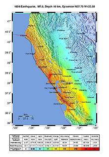
Although I was not alive during the San Francisco 1906 Earthquake, I thought it would be interesting to investigate one of the worst and most powerful earthquakes to ever hit the United States.
As I mentioned earlier, the San Andreas Fault runs through the entirety of California's length and is a transform fault. The San Andreas Fault is a tectonic plate boundary between the North American Plate and the Pacific Plate.

The image above shows San Francisco in 1905, approximately one year before the 1906 earthquake. Everything looks and seems to be alright here!


Although the Richter's scale did not exist back in 1906, there are widely agreed upon theories that suggest the earthquake had a moment magnitude of 7.9. The above images show the devastating effects of an earthquake with that amount of strength behind it. The foreshock struck the city at approximately 5:00am, with the main shock following around 20-30 seconds later. San Francisco was at the epicenter of the massive earthquake.
As if the destruction from the shaking were not enough, massive fires broke out within the city, contributing to the death toll of over 3,000 people. San Francisco had a population of just over 400,000 at the time.
Ever since the 1906 earthquake, precautionary building fundamentals have been implemented into construction methods in San Francisco. However, according to the New York Times, half of buildings in the San Francisco area are considered to be extremely dangerous and if a large earthquake were to strike again, people would not be able to go back in for quite some time. One of the scariest parts when thinking about the present day buildings in San Francisco is that the area has major earthquakes that seem to strike every 140 years. It has been 151 years since the last major earthquake, which is incredibly scary. However, attempts to predict these events are not always incredibly accurate.
The main things people always ask about or comment on when I mention I am from the Bay Area revolve around why it is so expensive to live in San Francisco. The city has recognized appreciated property values which have, in turn, made its individual residents who make under $82,000 stand at the "Low Income Limit" and families of four who make under $117,000 stand there as well.

As a class, we have asked why people choose to live in hazardous locations, and why some choose to pay a premium to do so. San Francisco lies directly on the San Andreas fault, which is commonly seen destroying the city in movies created by Hollywood stars.
Although I was not alive during the San Francisco 1906 Earthquake, I thought it would be interesting to investigate one of the worst and most powerful earthquakes to ever hit the United States.
As I mentioned earlier, the San Andreas Fault runs through the entirety of California's length and is a transform fault. The San Andreas Fault is a tectonic plate boundary between the North American Plate and the Pacific Plate.

The image above shows San Francisco in 1905, approximately one year before the 1906 earthquake. Everything looks and seems to be alright here!


Although the Richter's scale did not exist back in 1906, there are widely agreed upon theories that suggest the earthquake had a moment magnitude of 7.9. The above images show the devastating effects of an earthquake with that amount of strength behind it. The foreshock struck the city at approximately 5:00am, with the main shock following around 20-30 seconds later. San Francisco was at the epicenter of the massive earthquake.
As if the destruction from the shaking were not enough, massive fires broke out within the city, contributing to the death toll of over 3,000 people. San Francisco had a population of just over 400,000 at the time.
Ever since the 1906 earthquake, precautionary building fundamentals have been implemented into construction methods in San Francisco. However, according to the New York Times, half of buildings in the San Francisco area are considered to be extremely dangerous and if a large earthquake were to strike again, people would not be able to go back in for quite some time. One of the scariest parts when thinking about the present day buildings in San Francisco is that the area has major earthquakes that seem to strike every 140 years. It has been 151 years since the last major earthquake, which is incredibly scary. However, attempts to predict these events are not always incredibly accurate.
Fuller, Thomas, et al. “Buildings Can Be Designed to Withstand Earthquakes. Why Doesn't the U.S. Build More of Them?” The New York Times, The New York Times, 4 June 2019, www.nytimes.com/interactive/2019/06/03/us/earthquake-preparedness-usa-japan.html.
“The Great 1906 San Francisco Earthquake.” U.S. Geological Survey, earthquake.usgs.gov/earthquakes/events/1906calif/18april/.
“City Performance Scorecards.” Poverty in San Francisco | City Performance Scorecards, sfgov.org/scorecards/safety-net/poverty-san-francisco.
“1906 San Francisco Earthquake.” Wikipedia, Wikimedia Foundation, 7 Feb. 2020, en.wikipedia.org/wiki/1906_San_Francisco_earthquake.
Comments
Post a Comment